Professor Tian Yuntao’s team reported a new progressive tectonic model for explaining the formation of the southeast Tibetan Plateau
The Tibetan Plateau, the highest and largest orogenic plateau on the planet Earth, was mainly formed by the Cenozoic collision between the Indian and Eurasian plates after a series of Paleozoic-Mesozoic closure of ocean basins and subsequent collisions of continental blocks, providing a natural laboratory to understand the geodynamic processes of continental collision. The southeast Tibetan Plateau is considered as a crucial area to accommodate the post-collision deformation through large-scale escape of crustal materials and reactivation of pre-existing fault zones (e.g., the Ailaoshan-Red River shear zone). The development of the southeast Tibetan Plateau is thought to have strongly influenced the evolution of the Asian monsoon and proposed to be kinematically linked with the opening of the South China sea.
Existing end-member models sparked debates concerning plateau formation in the southeast Tibetan Plateau through early-middle Cenozoic transpressional and shortening deformation or late Cenozoic regional lower crustal flow with limited crustal shortening. The models, however, remain controversial. Cenozoic magnitude of shortening recorded by folding of Cretaceous-Paleogene basins is limited at an order of <20-10%, which is thus inconsistent with the regional crustal transpression and shortening model for forming the thickened crust (50-40 km) and elevated elevations (2-5 km). In addition, numerical modeling studies indicated that plateau-scale (1000s-km) flow of the lower crust requires an extremely low viscosity (1018-1016 Pa•s), which is one-two orders of magnitude lower than observations.
Professor Tian Yuntao’s team addresses the scientific problem by studying the spatiotemporal patterns of deformation and exhumation of the southeast Tibetan Plateau. The recent study of his team (Zhang et al., 2022), published in the top journal Earth-Science Reviews (with an impact factor of 12.4), synthesized new and published structural and thermochronological data. Their results show that the southeast Tibetan Plateau experienced two main phases of deformation during the Cenozoic: (1) spaced late Eocene-early Miocene crustal shortening and thickening along major fault zones, including the Ailaoshan-Red River, the Xianshuihe-Xiaojiang and Yalong-Yulong faults (Fig. 1a), and (2) late Miocene deformation and exhumation that is widely distributed within and away from the major faults (Fig. 1b). New structural analysis in the Yuanmou area, bounded by the major fault zones, reveals an open ~N-trending antiform, which is named as the Yuanmou antiform, outcropping Precambrian basement in core, mantled by Mesozoic- Cenozoic strata. The youngest strata (upper Cretaceous-Paleogene) involved in the folding are unconformably overlain by undeformed late Miocene deposits, suggesting that the antiform accommodated a phase of early-middle Cenozoic ~E-W contraction, whose shortening rate is estimated as ~9% (Fig. 2). The timing of the folding is quantified as ~40–28 Ma by apatite (U-Th)/He and fission track data and inverse thermal history modeling (Fig. 3). The study shows that late Eocene-early Miocene crustal shortening and surface uplift mainly occurs along major fault zones, with limited shortening in the intervening regions. Such a shortening pattern and history suggests the formation of the regional crustal thickening and surface uplift should have occurred in the late Miocene time.
Based on these results, Zhang et al. (2022) proposes a new progressive deformation model to explain the deformation history and the regional crustal thickening (Fig. 4). The model infers that the spaced late Eocene-early Miocene shortening thickened the crust beneath major fault zones and progressively led to the late Miocene lateral diffusive expansion of the mid-lower crust after sufficient thermal weakening at a timescale of ~30–20 Myr. The expansion of the weakened mid-lower crust resulted in regional crustal thickening and surface uplift in the southeast Tibetan Plateau. Such a process explains many geological and geophysical observations in the SE Tibetan Plateau, such as the development of branches of weak mid-lower crust beneath major fault zones, the time lag between the late Eocene - early Miocene crustal shortening and late Miocene regional surface uplift and river incision, together with limited amount of late Cenozoic shortening.
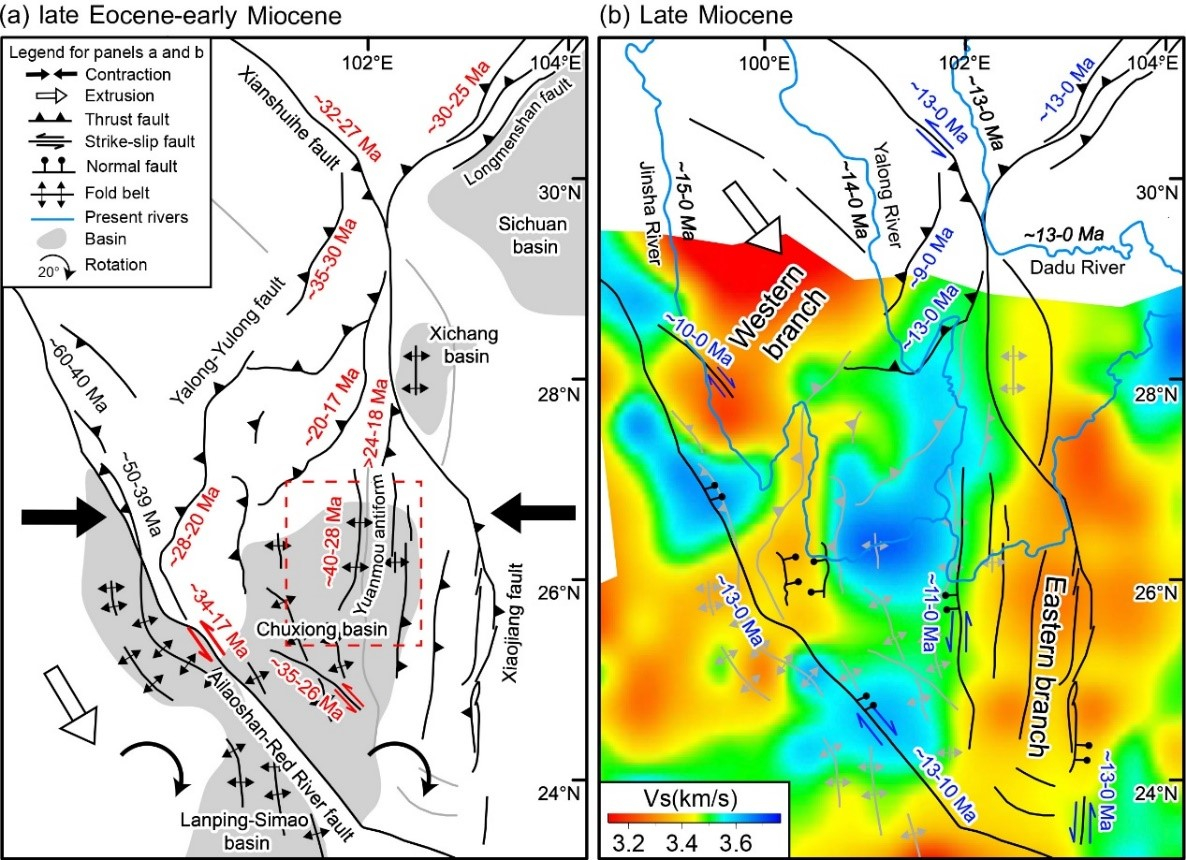
Fig 1. Time series of the Cenozoic deformation and exhumation evolution of the southeast Tibetan Plateau, showing the location, timing and kinematics for the Late Eocene – early Miocene (a) and late Miocene (b) phases of deformation and rapid exhumation. Time intervals in red (in panel a) and blue (in panel b) mark the timing of deformation; whereas those italic and black ones (in panel b) denote the river incision in areas distant from large fault zones. Structures in grey are inactive and activity-unknow during the time spans. The background of panel b is a tomographic image of shear-wave velocity at a depth of 21 km, showing two branches of the low velocity anomalies in the middle crust.

Fig. 2. Sequential restoration of the deformation history of the study area. (a) Simplified geological cross-section across the Yuanmou antiform. In this panel, Cretaceous and Paleogene strata are merged into one structural layer, due to their conformable contact. (b) Restoration of the late Paleogene folding and erosion, as evidenced by the angular unconformity between the late Miocene and the Cretaceous - Paleogene strata. The balanced cross-section suggests a minimum erosion of ~2 km based on the thickness of the relic strata. (c) Balancing of the Cretaceous – Paleogene strata shows a shortening of 4.3 km with a shortening rate of ~9%. (d) Late Jurassic shortening and juxtaposition of the basement against the Jurassic strata by reverse faulting. (e) Balancing the Jurassic strata shows 4.9 km shortening with a shortening rate of ~10%.

Fig. 3. Inverse thermal modeling results (right panels) and comparison between the observed and predicted data (left panels) for the Panzhihua (a), Yuanmou (b) and Hongge (c) transects, respectively. The thermal history of the uppermost sample is depicted by thick blue curve. The thin blue curves correspond to the 95% confidence intervals, reflecting the uncertainty in the inferred thermal history. The thermal history of the lowest elevation sample is depicted by red curve. The thin red curves correspond to the 95% confidence intervals, reflecting the combined uncertainty in the inferred thermal history and the temperature offset. The thermal histories of the intermediate samples are depicted by gray curves. Black boxes mark prior geological constraints. Right panels: plots compare the observed and predicted AFT ages, mean track lengths (MTL) and corrected AHe ages.

Fig. 4. Cartons illustrating geodynamic mechanisms for the growth and uplift of the southeast Tibetan Plateau, in which the crustal deformation is marked by deformed marker grids. The cyan, yellow and green patches in cross-sections denote the upper, middle and lower crust, respectively; whereas the gray marks the melt-weakened middle-lower crust. (a) The late Eocene-early Miocene phase of tranpressional shortening resulted in significantly crustal thickening and surface uplift along major fault zones. (b) The overthickened crust beneath these fault zones caused partial melting of the lower crustal after sufficiently thermal weakening at a timescale of ~30-20 Myr. The weakened lower crust flows outward, resulting in passive crustal thickening and surface uplift of the surrounding areas since the late Miocene. Note that the topography is exaggerated to highlight the elevation changes on the surface.
The paper is published in the journal Earth-Science Reviews. The full reference information is below:Zhang, G., Tian, Y., Li, R., Shen, X., Zhang, Z., Sun, X. and Chen, D., 2022. Progressive tectonic evolution from crustal shortening to mid-lower crustal expansion in the southeast Tibetan Plateau: A synthesis of structural and thermochronological insights. Earth-Science Reviews, 226: 103951.
图文:张贵洪、田云涛
初审:黄荣
审核:张照
审核发布:何晓钟

